LiDAR aerial surveying, topography, and integrated land solutions for transmission lines, highways, railways, mining, and large-scale infrastructure projects.

Services we provide

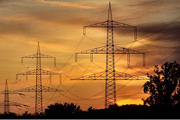
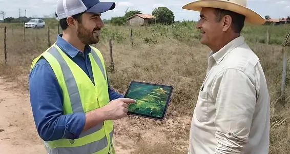
Land & Property (Land Management)

Altais organizes the land management process with territorial intelligence and technical rigor for projects in energy, highways, railways, mining, pipelines, and large-scale developments.

We operate from market research and price benchmarking, through permitting and studies, to the legal and physical registration of properties. This includes valuation reports, negotiation support, field due diligence, and managing the entire land regularization process.

Informed decisions and smooth execution — no surprises.

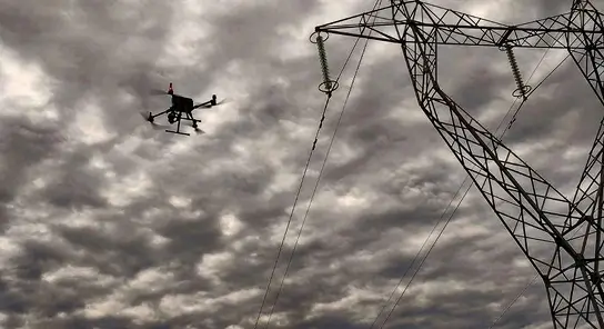
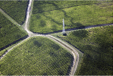
LiDAR Aerial Surveying + Photogrammetry

We carry out LiDAR aerial surveys combined with RGB photogrammetry to generate dense point clouds, DTMs, DSMs, contour lines, orthophotos, and highly reliable mapping products — even in areas with dense vegetation, complex terrain, and large extents.

Ideal for highways, railways, mining, energy, and pipelines, delivering a solid technical foundation for project design and execution planning.
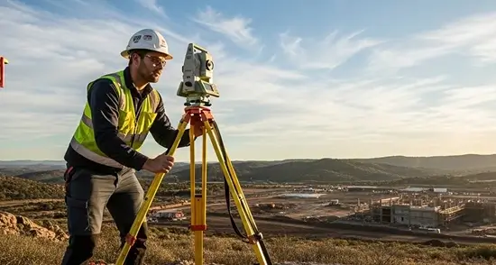
More predictability, less rework, and faster decision-making.

Topography

We perform topographic surveys with method, traceability, and a strong focus on productivity — from preliminary studies to full support for project implementation and construction monitoring.

We work across infrastructure, mining, highways, railways, industry, and energy sectors, with a team prepared for field routines and delivering results aligned with engineering and inspection requirements.

Topography is more than measurement: it’s control, technical safety, and a foundation for progress.

Explore Some of Our Projects

Take a look at some of the projects developed by the ALTAIS Geomatics team across a variety of fields.

ALTAIS Geomatics is a company specialized in geotechnology, focused on efficiency and quality. We have skilled professionals committed to seeking innovative solutions and market advancements to meet our clients’ needs.

Mission

To generate reliable territorial intelligence that supports strategic decision-making and enables infrastructure projects with technical precision, efficiency, and predictability.

Vision

To be a benchmark in geotechnology applied to infrastructure, recognized for data reliability, technical excellence, and contributions to the predictability and safety of large-scale projects.

Values

Technical Precision
Methodological rigor and quality control to ensure reliable information for engineering.

Data Reliability

Production and processing of geospatial data with traceability and consistency to support confident decision-making.

Project Predictability
Structured territorial information to reduce uncertainties and support project planning and execution.

Territorial Responsibility
Respect for people, properties, and the territory at every stage of the work.

Applied Innovation
Continuous use of technologies and methodologies that enhance project efficiency and quality.

Our history

Altais Geomatics has been operating for over three decades, developing geotechnology solutions for infrastructure projects. Throughout its trajectory, the company has participated in major projects in the energy and large-scale construction sectors, providing cartographic and territorial data that support engineering decisions from planning through to implementation.

With a strong presence in transmission line projects, Altais was a pioneer in applying laser profiling to transmission lines in Brazil, continuously incorporating new technologies and methodologies to enhance the quality and efficiency of its surveys.

Today, the company integrates LiDAR aerial surveying, topography, and land management, delivering reliable data and technical support for projects that demand precision, traceability, and confidence in decision-making.

Areas of expertise

Energy

Reliable territorial data for power generation and transmission projects.

Altais Geomatics develops cartographic and territorial datasets for energy generation, transmission, and distribution projects. Through LiDAR aerial surveying, topography, and land intelligence, we support everything from feasibility studies to the implementation of transmission lines and substations—ensuring accurate data for engineering and planning.

Infrastructure

Accurate territorial information for large-scale logistics and mobility projects.

We carry out geospatial surveys and analyses that support highway, railway, and logistics corridor projects. Using LiDAR aerial surveys, orthophotos, and high-precision topography, we provide essential data for route studies, detailed design, and construction monitoring.

Agriculture

Geotechnology applied to efficient agricultural land management.

Altais develops mapping and geospatial analyses focused on precision agriculture. Our solutions include terrain models, thematic maps, and terrain analysis that contribute to production planning and the management of large agricultural areas.

Selected projects

Transmission Lines Installed

Digital cartography, laser profiling, and topographic services for the construction of power transmission lines located in the states of Bahia and Tocantins.

  • 772 km of Transmission Lines

Wind Farm Implementation

Topographic surveys carried out using airborne LiDAR (planialtimetric survey) and aerial photogrammetry in the states of Paraíba and Rio Grande do Norte.

  • Wind Farm Implementation – 614 km²

Transmission Lines Installed

Digital cartography, laser profiling, and topographic services for the construction of power transmission lines located in the state of Maranhão.

  • 628 km of Transmission Lines

Transmission Lines Installed

Topographic surveys carried out using airborne LiDAR (planialtimetric survey) and aerial photogrammetry in the states of Paraíba and Rio Grande do Norte.

  • 243 km of Transmission Lines
  • 296.5 km of Transmission Lines
  • 162 km of Transmission Lines

Transmission Lines Installed

Digital cartography, laser profiling, and topographic services for the construction of power transmission lines located in the states of Pará and Tocantins.

  • 563 km of Transmission Lines

Transmission Lines Installed

Topographic surveys carried out using airborne LiDAR (planialtimetric survey) and aerial photogrammetry in the states of Paraíba and Rio Grande do Norte.

  • 397.2 km of Transmission Lines
  • 125 km of Transmission Lines
  • 196 km of Transmission Lines

Transmission Lines Installed

Digital cartography, laser profiling, and topographic services for the construction of power transmission lines located in the state of Rio Grande do Sul.

  • 473 km of Transmission Lines
  • 266 km of Transmission Lines

Transmission Lines Installed

Topographic surveys carried out using airborne LiDAR (planialtimetric survey) and aerial photogrammetry in the states of Paraíba and Rio Grande do Norte.

  • 302 km of Transmission Lines
  • 120 km of Transmission Lines

Need to get in touch
with us?

Fill out the form below and we’ll get back to you as soon as possible.

If you prefer, you can also reach us through the contacts below:

Phone

(19) 3394 - 2062

Email

comercial@altais.com.br

Address

Rua das Orquídeas, 777, sala 315. Torre Business - Indaiatuba - SP

If you prefer, you can also reach us through the contacts below:

Phone

(19) 3394 - 2062

Email

comercial@altais.com.br

Address

Rua das Orquídeas, 777, sala 315. Torre Business - Indaiatuba - SP

Altais Geomática

Geotechnology and territorial intelligence
for infrastructure and large-scale projects.

© 2026 Altais Geomática. All rights reserved.